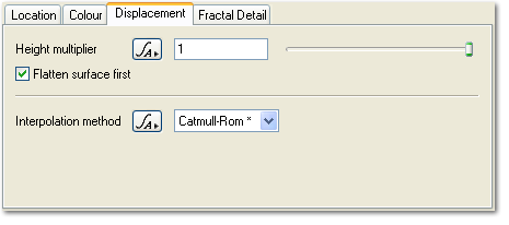
Heightfield Shader - Displacement Tab
Description: The Displacement tab controls how the values from the node connected to the Heightfield parameter are turned into displacement.
Settings:
- Height multiplier: This parameter multiplies the heights from the heightfield. The default value of 1 will leave the heights unchanged. A value of 2 will double the heights. A value of 0.5 will make them half as high.
-
Flatten surface first: If this checked the planet surface underneath the heightfield is flattened before the heightfield displacement is applied.
-
Interpolation method: This controls how the heightfield values are interpolated inbetween actual height values.
-
Back to: Heightfield Shader
A parameter is an individual setting in a node parameter view which controls some aspect of the node.
Literally, to change the position of something. In graphics terminology to displace a surface is to modify its geometric (3D) structure using reference data of some kind. For example, a grayscale image might be taken as input, with black areas indicating no displacement of the surface, and white indicating maximum displacement. In Terragen 2 displacement is used to create all terrain by taking heightfield or procedural data as input and using it to displace the normally flat sphere of the planet.
A heightmap or heightfield is an array of height values, usually in a grid which describe the height at specific points in a defined area. Heightfields are used to represent real-world and virtual terrain in a specific, easily converted format. Most heightfields can be represented as simple image data in grayscale, with black being minimum height and white being maximum height.
