Difference between revisions of "Heightfield Load"
| Line 5: | Line 5: | ||
'''Node Description and Purpose'''<br /> | '''Node Description and Purpose'''<br /> | ||
The Heightfield load node loads heightfield data from a file. It supports Terragen terrains in .ter files as well as many image types, including GeoTIFFs. | The Heightfield load node loads heightfield data from a file. It supports Terragen terrains in .ter files as well as many image types, including GeoTIFFs. | ||
| + | |||
| + | The Heightfield load node will automatically try to load georeferencing data for TIFF files. The georeferencing data is loaded from .tfw files, which should be in the same location as the TIFF. | ||
<br /><br /> | <br /><br /> | ||
'''Settings:''' | '''Settings:''' | ||
Revision as of 01:41, 7 October 2011
Node Type: Heightfield Operator
Node Description and Purpose
The Heightfield load node loads heightfield data from a file. It supports Terragen terrains in .ter files as well as many image types, including GeoTIFFs.
The Heightfield load node will automatically try to load georeferencing data for TIFF files. The georeferencing data is loaded from .tfw files, which should be in the same location as the TIFF.
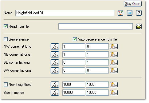
Settings:
- Read from file: If this setting is checked then the heightfield will load its data from the specified file. Click the File button on the right to open a file chooser dialog.
- Georeference: If this is checked the heightfield will be georeferenced according to the settings in the fields below.
- Auto georeference from file: If this is checked the node tries to load georeferencing information for the loaded file. This is on by default so if when you a create a new node and choose a file format which supports georeferencing the information will be loaded automatically. If the node finds georeferencing information when it loads the file it also turns on the Georeference param.
- NW corner lat long: This sets the latitude and longitude of the northwest corner of the heightfield.
- NE corner lat long: This sets the latitude and longitude of the northeast corner of the heightfield.
- SE corner lat long: This sets the latitude and longitude of the southeast corner of the heightfield.
- SW corner lat long: This sets the latitude and longitude of the southwest corner of the heightfield.
- New heightfield: If this setting is checked the node creates a new blank heightfield.
- Number of points: This param sets the number of points in the X and Y directions for the new heightfield.
- Size in metres: This sets the size in the X and Y directions for the new heightfield.
Statistics
- XY Size (metres): This param displays the size of the heightfield as loaded from the file. For example when you load an image TG2 makes each pixel in the image one metre in size. A 300 pixel wide image will be 300 metres across. Although this param is editable changing the settings has no effect. The param is only editable to allow you to easily copy the values from the field. You may want to do that so you can easily made an image overlay the same size as the heightfield. Please note that the XY Size doesn't correctly represent the size the heightfield size if the heightfield is georeferenced.
- Height Range: This field displays height information about the heightfield. It shows the minimum height, maximum height and the height range. The height range is the minimum height subtracted from the maximum height.
A heightmap or heightfield is an array of height values, usually in a grid which describe the height at specific points in a defined area. Heightfields are used to represent real-world and virtual terrain in a specific, easily converted format. Most heightfields can be represented as simple image data in grayscale, with black being minimum height and white being maximum height.
A single element of an image which describes values for color and/or intensity, depending on the color system which the image uses. Groups of ordered pixels together form a raster image.
